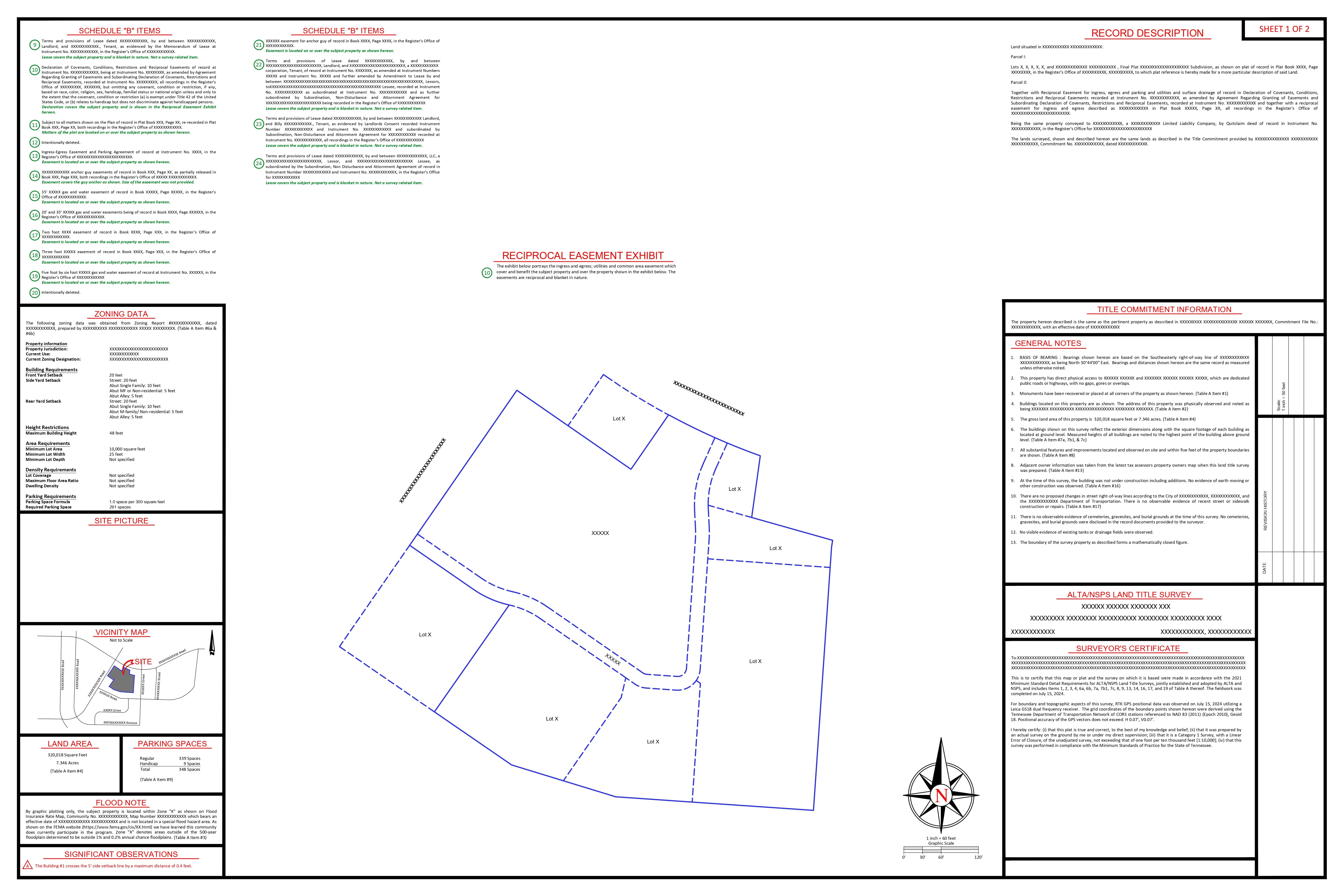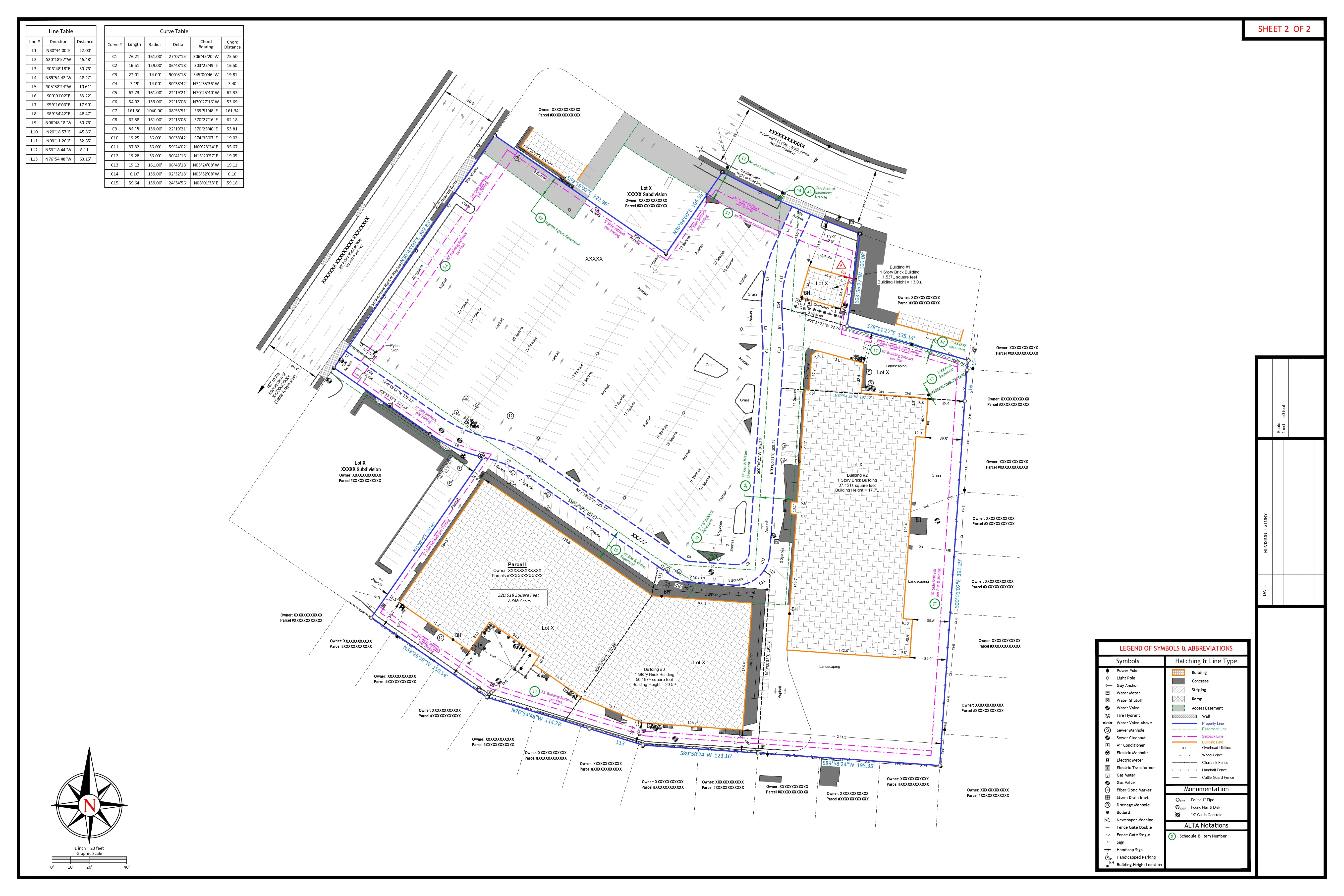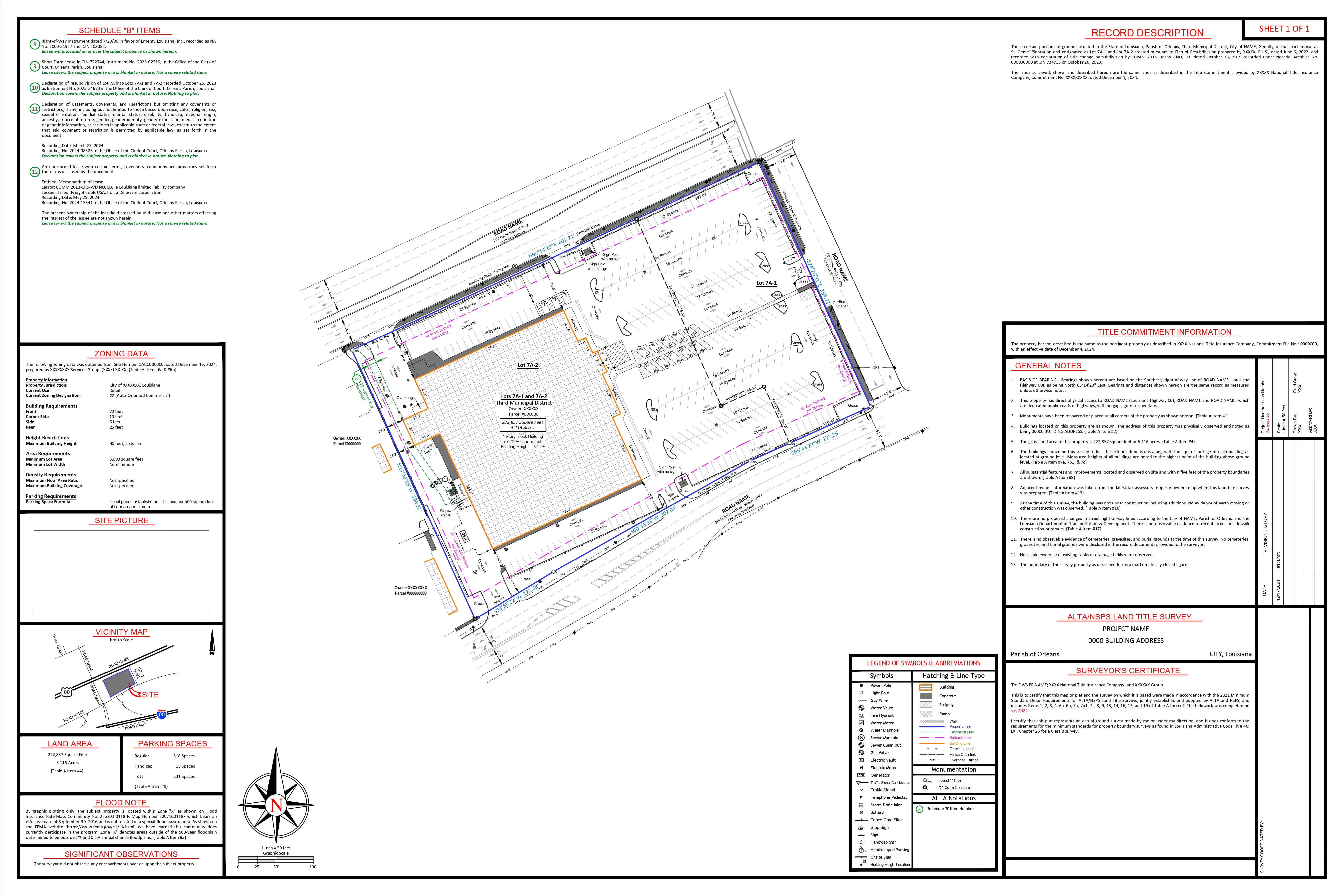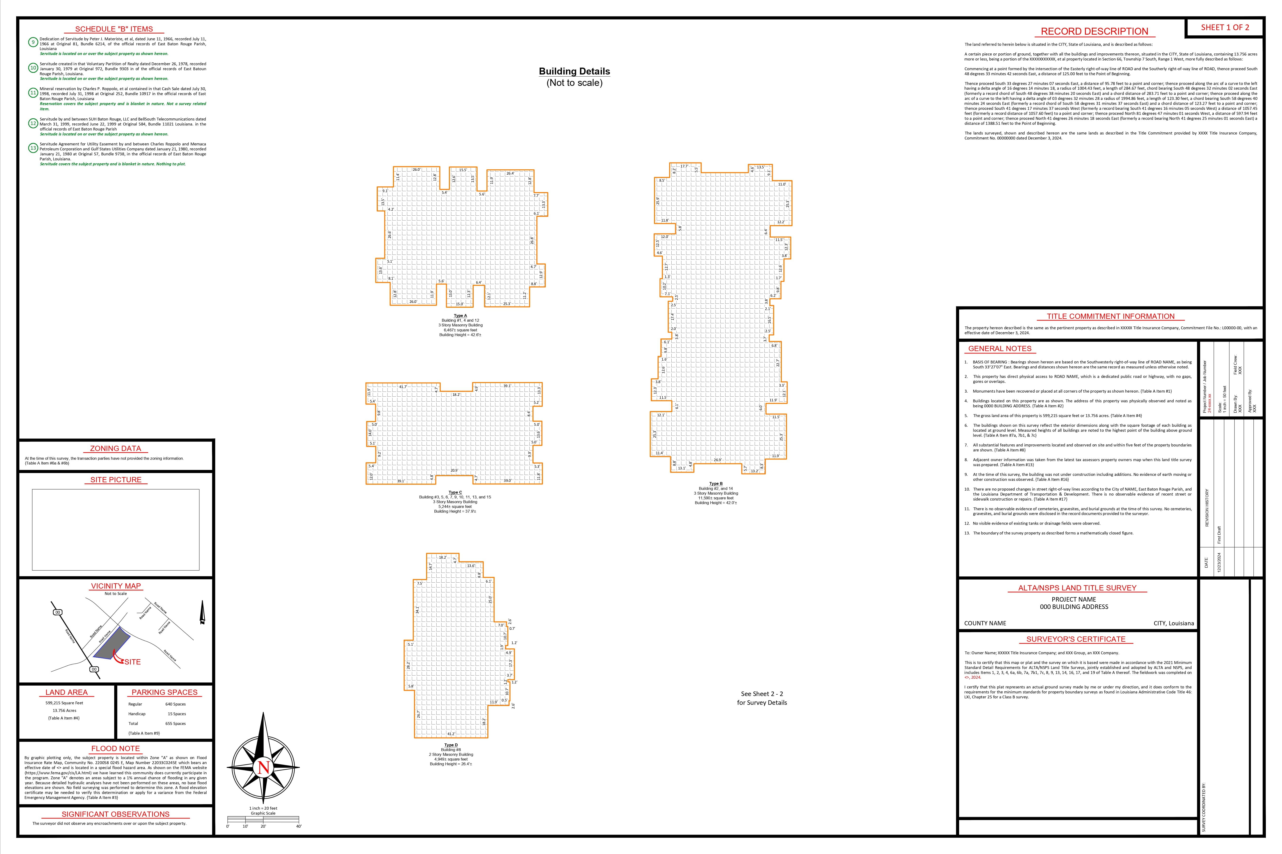

The Problem Every Project Manager Must Solve
When managing infrastructure projects, this question likely arises often: “Should we use traditional surveying techniques, or do we invest in LiDAR technology?” Considering the amount of major project consultations I’ve worked on, I can tell you there are both magnificent successes and spectacular errors. Most of the time, however, the answer is not what people expect.
The truth of the matter is, the real discussion is not centered around what technology is better, but rather determining the conditions which each approach’s application will maximize success in relation to costs, timelines, and deadlines.
What This Means for Your Bottom Line
Let me cut straight to what matters most: project outcomes and ROI. Here’s what our analysis of recent projects reveals:
| Business Impact Metric | Traditional Methods | LiDAR Technology | Improvement |
| Data Collection Rate | 50-100 points/hour | 100,000-2M points/second | 10,000x+ faster |
| Field Time (12-mile highway) | 18 days | 6 hours | 97% reduction |
| Labor Efficiency | Baseline | 70-80% time reduction | Significant savings |
| Design Change Orders | Baseline | 67% reduction | Major cost savings |
| Clash Detection Issues | Baseline | 78% reduction | Risk mitigation |
| Project Breakeven Point | N/A | 15-20 acres | Clear ROI threshold |
| Processing Cost | Minimal | 60-70% of project cost | Higher overhead |
| Accuracy (Vertical) | ±3-5mm | ±1-15cm | Trade-off consideration |
Real-World Project Examples:
- Highway corridor survey: 12-mile project using LiDAR completed in 6 hours versus 18 days with traditional methods.
- Disaster response: 27 damaged bridges surveyed in 3 days versus weeks using conventional methods.
- Hospital renovation: Reduction in clash detection using terrestrial LiDAR for MEP documentation.
- Volume calculations: LiDAR methods found to be 9.4% more accurate than traditional cross-section approaches
The Strategic Framework: When to Choose What
Based on our project experience, here’s the decision framework I recommend to clients:
Choose Traditional Surveying When:
- Non-negotiable precision needs to be upheld (±3-5mm accuracy required)
- There is small scale project (15 acres or less)
- Solely cost sensitive is the primary concern
- There is legal boundary work that needs to be done
- Construction staking requires placement of features at precise location
Best applications: Property boundaries, construction layout, precise engineering measurements, control networks
Choose LiDAR When:
- Comprehensive data provides additional project value
- Large areas need surveying (20+ acres)
- Inaccessible terrain poses safety or access challenges
- Time constraints are critical
- 3D modeling and visualization are project requirements
- Volume calculations need high accuracy
Best applications: Topographic mapping, as-built documentation, environmental monitoring, disaster response
The Hybrid Approach (Our Recommended Strategy):
For more sophisticated work and projects, the most incorporate both toward technology approaches to obtaining the desired result:
- Use conventional work for control networks and guaranteed high precision points
- Use flexible circled equipment which were LiDAR equipment sensors coverage demonstrative tools
- Check measurement routinely conventional and scope-fixed verify that means critical measurements of conventional means
- Result: With regards to achieving core milestones, 78% of major engineering did letiese iste interm noossan stvillebui this way integrated approach use.
Making the Investment Decision: What You Need to Know
Equipment Costs (2024 Pricing):
| Equipment Category | Product/Service | Price Range |
| Traditional Total Stations | Leica TS16 | $25,000-$35,000 |
| Trimble S7 | $22,000-$30,000 | |
| Topcon GT Series | $18,000-$28,000 | |
| GNSS Systems | Leica GS18 T Smart Antenna | $15,000-$20,000 |
| Trimble R12i | $20,000-$25,000 | |
| Data Collection & Software | Carlson CR+ with SurvCE | $5,000-$7,000 |
| AutoCAD Civil 3D (perpetual) | $7,000 + annual maintenance | |
| Microsurvey FieldGenius | $3,000-$5,000 | |
| Total Traditional Investment | $40,000-$70,000 | |
| LiDAR Equipment | Product/Service | Price Range |
| Entry-Level Terrestrial | Leica BLK360 | $17,000-$25,000 |
| Mid-Range Terrestrial | FARO Focus S70 | $50,000-$65,000 |
| Advanced Terrestrial | Riegl VZ-400i | $120,000-$150,000 |
| Hybrid Systems | Trimble SX10 Scanning Total Station | $40,000-$60,000 |
| Mobile LiDAR | Velodyne Alpha Prime | $75,000-$100,000 |
| Drone-Mounted | DJI Matrice 300 RTK + Zenmuse L1 | $23,000-$30,000 |
| YellowScan Surveyor Ultra | $90,000-$120,000 | |
| Processing Software | Leica CloudWorx | $10,000-$15,000 + subscription |
| Bentley ContextCapture | $25,000-$30,000 annual | |
| Terrasolid Suite | $20,000-$30,000 | |
| Autodesk ReCap Pro | $315/month or $2,420/year | |
| Total LiDAR Investment | $90,000-$600,000+ |
Service Provider Options:
| Service Type | Provider/Model | Pricing |
| Traditional Survey Services | Standard hourly rates | $150-$250/hour |
| Subdivision surveys | $2,500-$5,000 typical | |
| LiDAR Collection Services | Woolpert LiDAR Services | $3,000-$6,000/day + processing |
| Quantum Spatial (NV5) Mobile | $4,000-$8,000/day | |
| SAM Integrated Services | $2,800+/day | |
| Equipment Rentals | BLK360 rental | $750/day |
| High-end systems | $2,500/day | |
| Drone Services | Phoenix LiDAR DaaS | $2,500+ per project |
| Aero-Graphics fixed-wing | $0.50-$1.20 per acre |
The Technology Performance Reality Check
Let me give you the unvarnished truth about what each technology actually delivers:
| Performance Factor | Traditional Surveying | LiDAR Technology |
| Data Collection Speed | 50-100 points per hour | 100,000-2,000,000 points per second |
| Field Time (50-acre site) | 3-5 days | 3-6 hours |
| Vertical Accuracy | ±3-5mm (optimal conditions) | ±1-15cm (system/condition dependent) |
| Equipment Cost | $15,000-$40,000 | $50,000-$500,000+ |
| Labor Requirements | High (extended field time) | Lower collection; higher processing |
| Data Density | Sparse, targeted points | Comprehensive coverage (millions) |
| Vegetation Penetration | Limited by physical access | Partial penetration with aerial systems |
| Inaccessible Areas | Generally not possible | Often possible with aerial/mobile |
| Processing Complexity | Low to moderate | Moderate to high |
| Processing Time | Hours | Hours to days (dataset dependent) |
| 3D Visualization | Limited (point-based) | Excellent (complete environments) |
| Post-Collection Flexibility | Limited (return to site needed) | High (virtual revisits possible) |
| Weather Sensitivity | Moderate | High (especially aerial) |
| Power Requirements | Low (8-10 hours battery) | High (2-4 hours battery) |
| Data Storage Needs | Minimal (MB range) | Substantial (GB to TB range) |
Risk Management: Avoiding Common Pitfalls
In my experience as a consultant, these are the common pitfalls that will inevitably waste a project’s time and money:
Traditional Surveying Risks:
- Overly optimistic estimates for field time needed
- Safety concerns in difficult terrain
- Data deficiencies leading to follow-up appointments
- Minimal background knowledge relevant to design teams
LiDAR Implementation Risks:
- Overvaluation of what accuracy could be achieved
- Underestimation of how complex processing would be and its associated costs
- Insufficient training of staff on the new processes
- Lack of acceptance from regulators in certain regions
Our Strategic Recommendations
For Smaller to Medium Sized Projects (Under 20 Acres)
Do not deviate from standard practices unless there are particular LiDAR benefits (areas that cannot be accessed, 3D imaging) that merit costs.
For Larger Projects (Over 50 Acres):
LiDAR usually offers the best value in terms of time and the amount of data gathered. Supplement with the use of traditional control points.
For Complicated Infrastructure:
Employ a hybrid approach that combines traditional accuracy with LiDAR coverage. This has yielded the best results out of all other strategies from our project portfolio.
For Business As Usual:
If you consistently manage projects larger than 25 acres or require quick responsiveness, consider developing internal LiDAR capabilities.
The Future Landscape: Preparing for What’s Next
The technology evolution isn’t slowing down. Here’s what we’re tracking for our clients:
- Market expansion: This is expected to increase by a rate of 22.7% CAGR until 2028.
- Cost minimization: LiDAR hardware costs reduced by 32% over the past 5 years.
- Advancements in processes: Through automated classification, there will be an 85% reduction in manual labor required.
- Integration direction: There is expected to be near universal adoption of hybrid approaches in 5 years.
Optimizing Business: The Action Plan
Step 1: Analyze your project portfolio
- Determine the yearly acreage covered in the survey.
- List the repeating use cases.
- Assess the prevailing cost model.
Step 2: Run pilot testing
- Collaborate with service providers to complete initial projects.
- Evaluate results using benchmarking against traditional approaches.
- Calculate ROI on pilot projects.
Step 3: Construct capabilities
- Custom train current LiDAR staff in survey operations (heritage surveyors do not require much adjustment).
- Develop proven ROI equipment. The return on investment needs to be assured first.
- Build processing work flows.
Step 4: fine-tune your operations
- Implement hybrids.
- Create uniform standard control rules.
- Refine and check continuously.
The Bottom Line
Having implemented many projects, the most effective organizations do not settle for mastering one option – traditional surveying versus LiDAR. They strategically make use of both where applicable.
The issue at hand is no longer whether LiDAR will replace traditional surveying (it won’t). It is how fast you can master the use of both technologies to suit your project’s needs.
Strategically informed organizations tend to perform much better than those adopting technology without a carefully reasoned approach or failing to adopt technology due to an inflexible mindset. The former consistently outpace competitors as a result.
Ready to Optimize Your Surveying Strategy?
Unlocking the potential of every project starts with understanding that uniqueness lies at the core of each endeavor. If you are assessing surveying technologies for potential or existing projects, there is an opportunity to optimize your current approach based on insights I would like to share.
Imagine for a moment focus shifts to strategic deployment of technology: unlike the scenario where benefits remain ambiguous in terms of project outcomes, costs, and even competitive edge. Embrace the alternative: the question shifts to whether the focus is on controlling outcomes or enables setting the terms as a leader in technology driven transformation.
References and Sources
- Jaboyedoff, M., Oppikofer, T., Abellán, A., et al. (2022). “Use of LIDAR in landslide investigations: A review.” Natural Hazards, 61(1), 5-28.
- Liscio, E., Guryn, H., & Stoewner, D. (2023). “Accuracy and Precision in Scanning: Comparing Photogrammetry and LiDAR for Crime Scene Documentation.” Journal of Forensic Sciences, 68(1), 195-203.
- American Society for Photogrammetry and Remote Sensing (ASPRS). (2023). “LiDAR Guidelines and Base Specification,” Version 2.1.
- Glennie, C., Brooks, B., Ericksen, T., et al. (2021). “Calibration and Accuracy Assessment of Terrestrial LiDAR Scanners.” Photogrammetric Engineering & Remote Sensing, 87(9), 692-706.
- International Federation of Surveyors (FIG). (2023). “The Surveyor’s Role in Monitoring, Positioning, and Analysis,” Working Group 5.3 Report.
- Remondino, F., Nocerino, E., Toschi, I., & Menna, F. (2022). “A critical review of automated photogrammetric processing of large datasets.” International Archives of the Photogrammetry, Remote Sensing and Spatial Information Sciences, XLII-2/W5, 591-599.
- Wilkinson, B. E., Mohamed, A. H., & Dewitt, B. A. (2021). “Achieving centimeter accuracy with LiDAR under canopy: A comparison of processing techniques.” ISPRS Journal of Photogrammetry and Remote Sensing, 172, 209-218.
- Zhang, W., Qi, J., Wan, P., et al. (2022). “An Easy-to-Use Airborne LiDAR Data Filtering Method Based on Cloth Simulation.” Remote Sensing, 14(3), 505.
- U.S. Geological Survey. (2023). “National Geospatial Program LiDAR Base Specification,” Version 2.0.
- Colomina, I., & Molina, P. (2021). “Unmanned aerial systems for photogrammetry and remote sensing: A review.” ISPRS Journal of Photogrammetry and Remote Sensing, 170, 115-127.
- Geospatial World Market Survey. (2024). “LiDAR Market Trends and Projections 2024-2030.”
- American Council of Engineering Companies. (2023). “Technology Adoption in Surveying and Geospatial Services,” Industry Report.
- Huber, D., Akinci, B., Tang, P., et al. (2023). “The Changing Economics of LiDAR in Civil Engineering Applications,” Civil Engineering Journal, 34(2), 145-159.
- National Transportation Research Board. (2023). “Design Change Order Reduction Through Advanced Survey Technologies,” Special Report 329.
- Li, Z., Chen, J., & Baltsavias, E. (2024). “Integration of LiDAR and Traditional Survey Methods: Best Practices.” International Journal of Geoinformatics, 20(1), 31-42.
The analysis provided is driven by extensive project data and substantive industry research. For targeted project recommendations, tailored cost-benefit evaluations, and bespoke multidisciplinary solutions, consultation services are provided.
Last modified: December 13, 2025